
For years, Environmental, Social and Governance (ESG) has largely been viewed through a corporate lens. Companies measure emissions, energy consumption, water use, employee wellbeing, governance practices and other sustainability indicators, increasingly translating them into structured reports and digital dashboards.
But there is a question that deserves greater attention:
What happens when we stop looking at ESG only from inside the corporate boundary?
A factory does not operate in isolation. An office does not exist independently from the city around it. Employees live in neighborhoods, travel through transport networks, depend on public infrastructure and interact with surrounding communities. Industrial facilities consume water from shared resources, discharge waste into wider environmental systems and face the same flooding, heat, pollution and climate risks as the communities around them.
In other words, every ESG issue has a place.
And once we recognize that, ESG begins to look remarkably similar to urban planning. Urban planning asks where people and activities are located, how infrastructure and land use interact, how environmental risks are distributed, how communities access essential services and how today's development decisions shape tomorrow's city. On contrary, ESG asks how organizations affect the environment, people and systems in which they operate.
The questions are different—but the system is often the same.
Where ESG Meets Urban Planning
The connection becomes clearer when the three ESG dimensions are viewed spatially.
Environmental × Planning
Floodplains, wetlands, drainage networks, heat-prone areas, air-quality hotspots and ecological assets all have geographic dimensions. ESG can therefore provide a sustainability lens for decisions about land use, industrial development, infrastructure and climate resilience.
An environmental indicator may tell us that a risk exists; its spatial context can tell us where that risk concentrates, what systems are connected to it and who may be affected.
Social × Planning
The “S” in ESG may have an even stronger connection with planning.
- Where do workers live?
- How long do they travel?
- Can they access affordable transport?
- Are healthcare and other essential services accessible?
- Which communities are disproportionately exposed to environmental hazards?
These are not only social indicators. They are spatial questions about accessibility, inclusion and equity. Two workers may have similar employment conditions, but very different experiences depending on where they live, how long they travel, what transport they can access and what environmental risks surround their communities.
This is where ESG's social dimension intersects directly with the spatial question of who has access, who is exposed and who is left behind.
Governance × Planning
Governance also extends beyond organizational policies. Land-use controls, regulations, institutional coordination, stakeholder participation, transparency and monitoring determine how different actors manage shared resources and risks. But governance becomes particularly important when a problem crosses organizational or administrative boundaries.
- Who manages the drainage system?
- Who controls land-use decisions?
- Who is responsible for protecting a waterbody?
- Who owns the data needed to understand the risk?
- And when a problem affects both a company and surrounding communities, who is accountable for addressing it?
Many urban risks are therefore not simply problems of missing data. They are also problems of fragmented responsibilities. In other words, governance determines not only how an organization manages its own risks, but how different actors respond to risks that no single organization can solve alone.
A Practical Example: A Garment Factory and the City Around It
Consider a garment factory in a rapidly urbanizing industrial area of Bangladesh. From an internal ESG perspective, the factory may be performing well:
Energy efficiency | Reduced water use | Responsible waste management | Worker safety | Environmental and social policies
But now place that factory on a map. The picture may change.
- Nearby worker settlements experience waterlogging.
- Public transport is limited.
- Drainage capacity is inadequate.
- Worker housing is expanding rapidly.
- Water bodies are being encroached upon.
- Emergency access is constrained by congestion.
The factory may reasonably argue that many of these problems fall outside its operational boundary. From a conventional reporting perspective, that may be true. But from a systems perspective, the boundary becomes harder to defend. The factory depends on roads, drainage, water, electricity, labor, housing, emergency services and the surrounding environment. At the same time, its operations interact with these systems and the communities that depend on them.
A factory can therefore be ESG-compliant within its own boundary while remaining exposed to—and potentially influencing—risks beyond it. A spatial assessment could bring together the factory location, worker distribution, land use, drainage, flood susceptibility, roads, water resources and community infrastructure. The analysis might reveal that:
- Improving drainage reduces both operational and neighborhood risk.
- Better worker transportation improves accessibility while reducing congestion.
- Protecting a nearby water body supports flood management, biodiversity and community resilience.
- More strategic worker-housing and transport planning can improve both social outcomes and operational resilience.
Suddenly, one planning intervention can create value across multiple ESG dimensions. That is the real opportunity: not simply making a company more sustainable within its boundary but understanding how corporate activity and urban systems can become more sustainable together.
GIS: The Bridge Between ESG and Planning
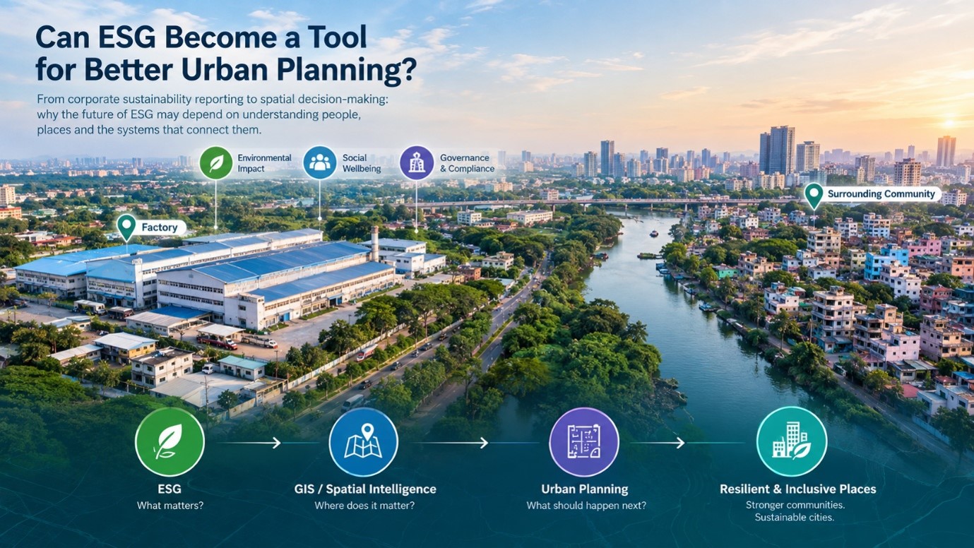
This is where GIS has become more than a mapping tool. ESG data may tell us about energy, emissions, water, waste, workforce, compliance and climate risks. GIS can connect those indicators to location, land use, population, infrastructure, transport, environmental assets, hazards and communities. That changes the questions we can ask.
Instead of: What is the ESG performance of this organization?
We can ask:
- “Where are its most significant environmental and social risks?”
- “Who is exposed to them?”
- “What systems influence those risks?”
- “Where could an intervention generate the greatest sustainability benefit?”
This is the shift from ESG reporting to spatial intelligence.
Can ESG Become a Tool for Better Urban Planning?
The answer may be yes—but only if ESG moves beyond the boundaries of the organization.
The future of sustainability will not depend solely on how efficiently a company operates within its own premises. It will increasingly depend on how its operations interact with people, infrastructure, resources, ecosystems and communities. Urban planning, meanwhile, can use ESG principles to better understand the environmental, social and governance consequences of development decisions. The real opportunity lies at the intersection:
- ESG tells us what matters.
- Spatial intelligence tells us where it matters.
- Urban planning helps us decide what to do about it.
Together, they offer a pathway from sustainability reporting to sustainability-informed development. And perhaps the most important question for the next generation of cities is not simply:
“Is this organization sustainable?”
but:
“Can the organization, the community and the city become more sustainable together?”
That is where the future of ESG may meet the future of urban planning.
Share this page via
More from Asma Amin Rimi